f. 7r., entire face of one folio (pictorial and textual)
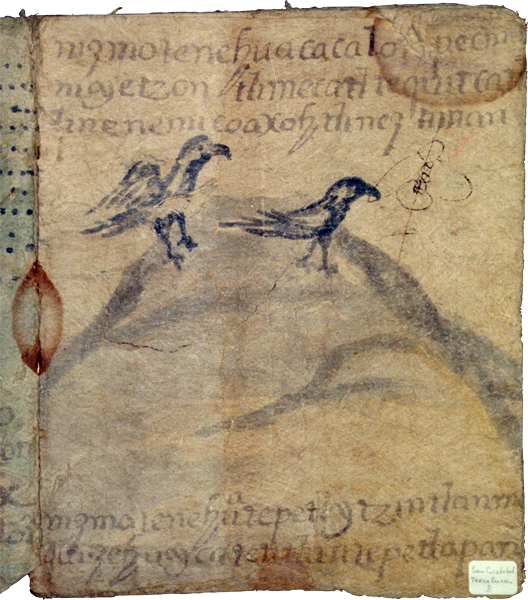
This page, which is the front side of the seventh folio (7 recto) of eighteen folios, is typical of the image-heavy pages that feature landscapes included in these territorial claims of San Cristóbal Texcalucan and Santa María Magdalena Chichicaspa in the municipality of Huixquilucan (modern State of Mexico) late in the Spanish colonial period.
On this page we see a hill or mountain, painted with a gray wash, and with two birds near the crest. Lines of text run across the top and bottom of the page.
A brown stain appears in the binding at about the middle of the page. Another stain appears in the upper right corner. A while paper label appears in the lower right corner of the page, identifying the pueblos with which this manuscript is associated.
The text tells that this area is called Cacalotepec (tentative reading; there is damage to the page), and the landholdings, for raising tributes, measure three tzontli (3 x 400, or 1,200) mecatl (cords), a measure of land in this vicinity. Some other places in the vicinity are highlighted at the bottom of the page, including Tepetl Itzintlan.
página entera de un folio (pintura y texto)
Esta página, que es la parte de enfrente del folio septimo (7 recto) de dieciocho folios, es típica de las páginas con imagen-pesada que documenta paisajes incluyendo estos reclamos territoriales de San Cristóbal Texcalucan y Santa María Magdalena Chichicaspa en el municipio de Huixquilucan (Estado de México) posteriormente en el período colonial Español.
En esta página vemos cerros o montañas, pintadas con un gris lavado, y con dos pájaros cerca de un nido. Líneas de texto corren sobre la parte de arriba y de abajo de la página.
Una mancha café aparece en la cubierta, en medio de la página. Otra mancha aparece en la esquina derecha de arriba. Una etiqueta de papel blanco aparece en la esquina derecha de abajo de la página, identificando los pueblos con los que este manuscrito es asociado.
El texto nos dice que esta área es llamada Cacalotepec (lectura indecisa; hay daño en la página), y las retenciones de tierra, para recaudar tributos, miden tres tzontli (3 x 400, o 1,200) mecati, una medida de tierra en esta vecindad. Otros lugares en la vecindad son destacados en la parte de abajo de la página, incluyendo Tepetl Itzintlan.