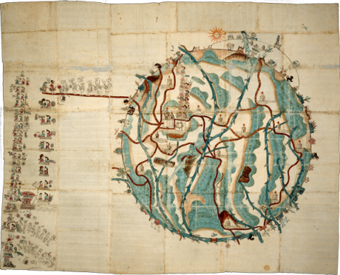
This pictorial manuscript, measuring 142 by 177 cm., dating from 1580, and relating to the Mixtec community of San Pedro Teozacoalco, in the modern state of Oaxaca, resides currently in the Benson Library at the University of Texas, Austin. The library kindly provided a digital image for publication in the Mapas Project. The Mapa de Teozacoalco is part of the map and manuscript genre called Relaciones Geográficas, produced in response to questionnaires that came from Spanish monarchs, seeking information about their colonies. This map was made in response to inquiries from the Spanish King Philip II. The Mapa de Teozacoalco, painted on twenty-three sheets of European paper pasted together at their edges, contains indigenous pictorial styles, but shows some European influence. The landscape, for instance, is dotted with new Christian churches. Roads show not only human footprints but also horseshoe prints. Emphasis resides in the history of Teozacoalco, with information about a tenth-century ruling family, and subsequent genealogy through the sixteenth century. The circular shape is worthy of special attention. The circle includes 46 glyphic placenames on the community’s territorial boundaries. The extra curve with glyphic placenames refers to an earlier set of boundaries. Alfonso Caso published a small book-length study of this pictorial map (1949, 1992), and Stephen L. Whittington has also published “The Mapa de Teozacoalco: An Early Colonial Guide to a Municipality in Oaxaca,” in The Society for American Archaeology (SAA) Archaeological Record 3:4 (2003), 20–22, and a report on the FAMSI website (http://www.famsi.org/reports/01032/section01.htm). Some of the information in this introduction comes from Barbara E. Mundy, "Mesoamerican Cartography." In: The History of Cartography, vol. 2.3, David Woodward and G. Malcolm Lewis, eds. 183–256. Chicago and London: University of Chicago Press, 1998. The lead scholar on this close study of the Mapa de Teozacualco is Bas van Doesburg. (Stephanie Wood)
Teozacualco, Mapa de
Title variants:
Teozacoalco Map, Mapa de la Relación Geográfica de Teozacoalco
Principal editor:
Bas van Doesburg
Transcriptions and Translations
| Analytic Transcription | English Translation | Literal Transcription | Spanish Translation | Standardized Transcription | |
|---|---|---|---|---|---|
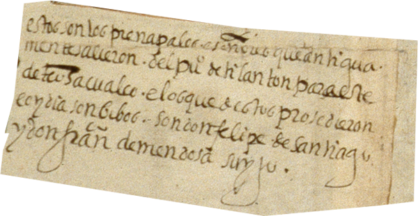 |
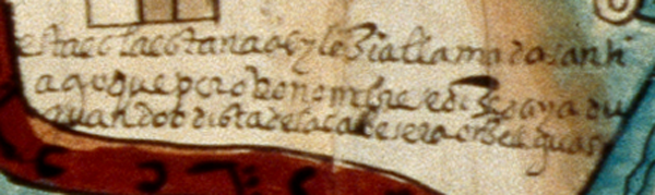
Estos son los prencipales e señores que antigua/mente salieron del pu[ebl]o de Tilanton[go] para este/ de Teosacualco, e los que destos prosedieron/ e oy dia son bibos son don Felipe de Santiago /y don Fran[cis]co de Mendosa, su yjo. | These are the nobles and lords that in ancient days left the town of Tilantongo for this one, [the town] of Teozacualoco, and those that descend from them and are alive today are don Felipe de Santiago and don Francisco de Mendoza, his son. | estos son los prencipales e señores que antigua/mente salieron del puo de tilanton para este/ de teosacualco e los que destos prosedieron/ e oy dia son bibos son don felipe de santiago /y don franco de mendosa su yjo. | Estos son los principales y señores que antiguamente salieron del pueblo de Tilantongo para este de Teosacualco, y los que de estos procedieron y hoy día son vivos son don Felipe de Santiago y don Francisco de Mendosa, su hijo. | |
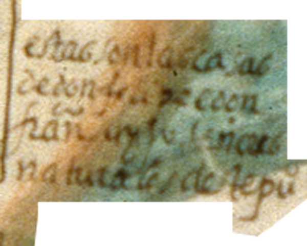 |
estas son las casas de don felipe e don fran[cis]co su yjo señores naturales deste pu[ebl]o | These are the houses of don Felipe and don Francisco, his son, hereditary lords of this town [of Teozacualco]. | |||
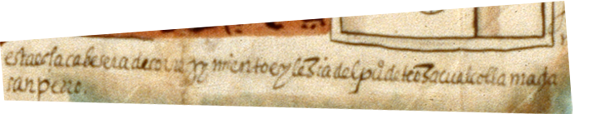 |
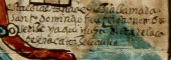
esta es la cabesera de correjymiento e y[g]lezia del pu[ebl]o de teozacualco llamado san pedro | This is the administrative center of the corregimiento and church of the town of Teozacualco, called San Pedro. | |||
 |
(.....sia) llamada san ju[an] que por otro nombre se dize teneixayu dista de la cabesera dos leguas | (... church) called San Juan, which by another name is known as Teneixayu, it is two leagues from the administrative center. | |||
 |
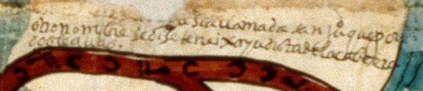
esta es la estançia e y[g]lezia del pu[ebl]o de (sa jesonimo) q[ue] por otro nombre se dize yutamañ(u) dista de la cabesera cuatro leguas | This is the estancia and church of the town of San Jerónimo, which is also known as Yutamañ(u). It is four leaguas from the administrative center. | |||
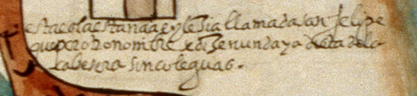 |
esta es la estançia e y[g]lezia llamada san felipe que por otro nombre se dize nundaya dista de la cabesera sinco leguas | This is the estancia and church called San Felipe, which is also known as Nundaya. It is five leagues from the administrative center | |||
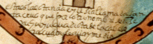 |
esta es la estancia e ylezia llamada san ta crus que por otro nombre se dize nuhuyu(?) que dista de la cabeser a cuatro leguas y media | This is the estancia and church called Santa Cruz that by another name is called Nuhuyu(?) that is four and a half leagues from the cabecera. | estaeslaestanciaeyleziallamadasan tacrus que por otronombre sedize nuhuyu(?)quedista de lacabese racuatro leguasymedia | Esta es la estancia e iglesia llamada Santa Cruz que por otro nombre se dice Nuhuyu(?) que dista de la cabecera cuatro leguas y media. | Esta es la estancia e iglesia llamada Santa Cruz que por otro nombre se dice Nuhuyu(?) que dista de la cabecera cuatro leguas y media. |
 |
esta es la estançia e y[g]lezia llamada san fran[cis]co que por otro nombre se dize cagua (cahua) dista de la cabesera cuatro leguas | This is the estancia and church called San Francisco, which is also known as Cagua (or Cahua.) It is four leagues from the administrative center. | |||
 |
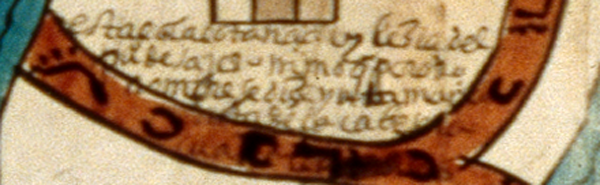
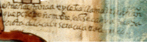
esta es la estançia e y[g]lezia llamada santi ago que por otro nombre se dize dayadu guandoo dista de la cabesera onze leguas | This is the estancia and church called Santiago, which is also known as Dayaduguandoo. It is eleven leagues from the administrative center. | |||
 |
esta es la estançia e y[g]lezia llamada santo domingo que por otro nombre se dize yaguinuhu dista de la ca besera catorze leguas | This is the small settlement (”estancia”) and church called Santo Domingo, also known as Yaguinuhu, fourteen leagues from the administrative center. |