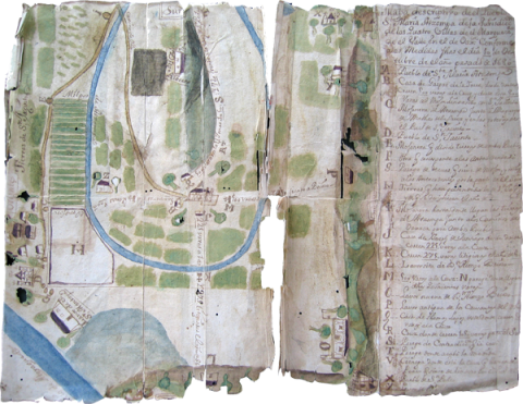
This map about the landholdings of Santa María Atzompa, Oaxaca, with texts in Spanish and painted in watercolor on European paper, apparently dates from the late seventeenth century. The map references some measurements of town lands that were made in or around 1686. While it was possibly made by a Spanish colonial official, we include it here because it relates to an indigenous community and its struggles to defend its territory. This was a critical time in the defense of pueblos (towns). Many were demanding recognition of their minimum town base (used for farming and not just the housing core) that would later come to be called the “fundo legal.” In 1686, this community-held land was being measured from the church, 500 varas out in the four cardinal directions. It would then be squared off at the corners. A year later, in 1687, a new law stipulated that indigenous communities in New Spain would be measured out for 600 varas and from the last houses in town. Then, in 1695, it was reigned back in somewhat, still to be in segments of 600 varas, but once again to be measured from the church. Still, this was a minimum allotment, and the law required that the authorities provide communities with additional land for the subsistence of their populations, as needed. As this particular case illustrates, at the time the measurements were being made (usually at a town’s request, not uniformly implemented), the 500 or 600 varas sometimes had to jog around or skip over intervening private properties. Given how close this town was to the provincial capital of Oaxaca, it is no surprise that we find several private properties (apparently owned by Spaniards) interspersed with indigenous community-held lands. Atzompa is a Zapotec town that lies about five kilometers from the capital of the state of Oaxaca, Mexico, and very near to the famous ruined city of Monte Albán. Atzompa has its own archaeological site, which has been under intense excavation since 2009, and is now open to the public. Its central ballcourt was the largest one in the area, believed to have been the principal one for Monte Albán. Atzompa is known today for its production of green, glazed ceramics, and a pottery oven dating from ca. 600–900 C.E. has been found at the Atzompa archaeological site. (Brief description by Stephanie Wood.)
Atzompa, Mapa de Santa María, 1686
Principal editor:
Stephanie Wood
Transcriptions and Translations
| Analytic Transcription | English Translation | Literal Transcription | Spanish Translation | Standardized Transcription | |
|---|---|---|---|---|---|
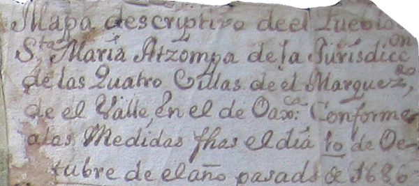 |
[Transcription of the Spanish by Stephanie Wood:] Mapa descriptivo de el Pueblo de Sta. María Atzompa de la Jurisdicc n de las Quatro Villas de el Marquezdo, de el Valle, en el de Oaxca: Conforme a las Medidas fhas el día 10 de Octubre de el año pasado de 1686 | [Spanish-to-English translation by Stephanie Wood:] Descriptive map of the Town of Santa María Atzompa of the Jurisdiction of the “Cuatro Villas” of the” Marquesado del Valle” in the [valley] of Oaxaca, corresponding to the measurements made on the 10th day of October of the past year, 1686. |