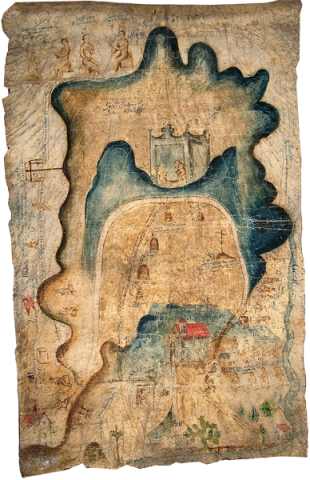
This is a pictorial manuscript, currently housed in the Museum of Natural and Cultural History at the University of Oregon. Painted with watercolors on animal hide, this important primary source for Zapotec cultural history, dating from the end of the seventeenth century (and perhaps copying something earlier and adding Spanish translations of the Zapotec glosses), contains cartographic, genealogical, and historical elements. It apparently relates to San Andrés Mixtepec in the state of Oaxaca, west of Miahuatlan. The town of Cuixtla also appears in the lower left corner of the painting. This pictorial hide narrates a migration from Zaachila to the site for the founding of the town of San Andrés (where the larger church with the red roof can be seen), highlighting significant stopping points along the migration route. The painting includes representations of the earliest ancestors in Zaachila as well as a genealogy of important figures in the town over many generations. Early in the genealogy, we see a person who had been baptized, taking a Christian name. Territorial boundary markers are another major feature on the landscape. (Brief description by Stephanie Wood; map analysis by Michel Oudijk and Don Dumond.)