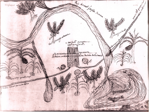
This is the Mapa de San Francisco Ocoapa, in what is now the state of Veracruz. This community was part of the historic province of Guazaqualco (which name lends itself to the modern city of Coatzacoalcos, today), and was rich in cacao production. Ocoapa had to produce a large number of cacao beans as part of its tribute requirement. See Sherburne F. Cook and Woodrow Borah, Essays in Population History: Mexico and California (Berkeley: University of Calfornia Press, 1979), vol. 3, p. 109. This map is located in the Archivo General de la Nación, Mexico. It is part of the Tierras collection, vol. 2, expediente 11, f. 11. The image has been provided to the Mapas Project by Amara Solari. Brief descriptions have been supplied by Stephanie Wood as place holders.
Ocoapa, Mapa de
Title variants:
Mapa de San Francisco Ocoapa
Principal editor:
Stephanie Wood and Amara Solari
Transcriptions and Translations
| Analytic Transcription | English Translation | Literal Transcription | Spanish Translation | Standardized Transcription | |
|---|---|---|---|---|---|
 |
[Transcription of the Spanish by Stephanie Wood:] esta un quarto de legua en canoa | [Spanish-to-English translation by Stephanie Wood:] it is a quarter of a league by canoe | |||
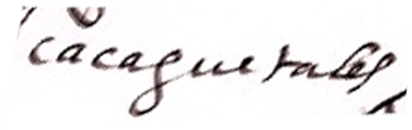 |
[Transcription of the Spanish by Stephanie Wood:] cacaguetales | [Spanish-to-English translation by Stephanie Wood:] cacao lands | |||
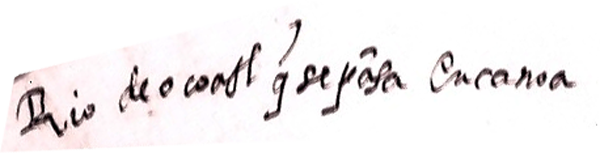 |
[Transcription of the Spanish by Stephanie Wood:] Rio de ocoatl qe se pasa en canoa | [Spanish-to-English translation by Stephanie Wood:] The river of Ocoatl that one can travel by canoe. | |||
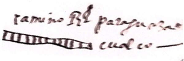 |
[Transcription of the Spanish by Stephanie Wood:] camino Rl para guazacualco | [Spanish-to-English translation by Stephanie Wood:] the royal road to Guazacualco |