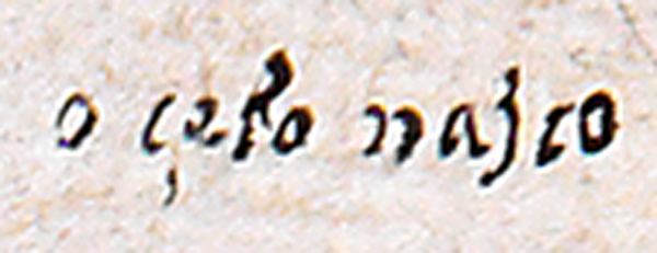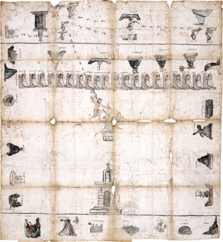
The Mapa de Xochitepec relates to an indigenous Mixtec community in the modern state of Oaxaca, Mexico. Today the town is called San Juan Bautista Suchitepec. Xochitepec, spelled variously, means Flower-Mountain. The manuscript dates from about 1580, at a time when many maps were being produced as a part of a royal investigation into the human and community resources in the Spanish colonies. These maps were largely made by indigenous painters and scribes, and that is true of this one. Certain features that point to indigenous authorship include the pre-Hispanic stylistics (such as footprints for roads or pathways) and hieroglyphic writing. The glosses with alphabetic writing, utilizing the Roman alphabet, are clues to its colonial-era composition, as are the names of some of the indigenous elites, such as "don Alonso" and "don Matheo," evidence that some enjoyed the Spanish title of nobility ("don") and had been baptized with Christian names. The close study of the details of this manuscript have been prepared by the Danish scholar, Jesper Nielsen, at the University of Copenhagen, where the manuscript now resides in the Ethnographic Collection of the National Museum of Denmark. Jesper Nielsen and Christophe Helmke write: "The manuscript has already been described by the historian Hans Christian Bjerg in the 1973 issue of Arbejdsmarken, but since then our understanding of such mapas and of Mesoamerican writing systems, including that of the Aztec, has grown tremendously. In the autumn of 2014 the Mapa de Xochitepec was the subject of new photography at the behest of the authors, and it is on the basis of these new studies that we present a review of the contents, and demonstrate how, among other things, it was undoubtedly produced by an Aztec, and not Mixtec, scribe, as well as taking another look at the European influences that are betrayed by certain elements of style. Finally, we have also been able to propose a plausible explanation for the means by which this unique document was acquired into the collections, since it is likely that the Mapa de Xochitepec was purchased by Christian Schleiden during his stay in Mexico between 1831 and 1833. Thereafter the manuscript was passed on to his son, Rudolph Schleiden, who in 1869 bequeathed it to the Museum." [SW] Acknowledgements: Jesper Nielsen wishes to thank Magnus Pharao Hansen for his kind help in providing translations of the Nahuatl toponyms, Laura Cano Rodríguez for sharing her excellent research on the Mapa de Xochitepec, and Christophe Helmke for their earlier collaboration in studying the document. References: Caso, Alfonso. 1958. El Mapa de Xochitepec. In: Proceedings of the Thirty-Second International Congress of Americanists, Copenhagen, 8-14 August 1956. Munksgaard, Copenhagen, pp. 458-466. Cano Rodríguez, Laura. 2015. El Mapa de Xochitepec: un ejercicio de geografía histórica de la Mixteca Baja a partir de su toponimia. In: Configuraciones territoriales en la Mixteca, Vol. 1. Estudios de historia y antropología. Ed. by Manuel A. Hermann Lejarazu, pp. 93-127. Nielsen, Jesper and Christophe Helmke. 2016. Beretningen om Blomsterbjerget – et sjældent mexicansk håndskrift i Etnografisk Samling. In: Nationalmuseets Arbejdsmark 2016. Ed. by Per Kristian Madsen and Ingrid Wass, pp. 80-91. The National Museum, Copenhagen.